


Phang Nga Bay
Phang-Nga Bay belong to the Andaman Sea who in turn belongs to the mightily Indian Ocean. Ao Phang-Nga( Ao=Thai language for Bay) has a surface of about 400 km2 and is, thanks to the heaven , since already 16 years a Thai National Marine Park. So by this no hotels, no resorts, no bars and no boutiques, no mass tourism. “Only pure nature at its best!”
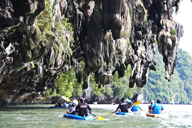
In the bay one will find 42 island and islets. To visit them all has no sense; all are beautiful but only are few and real spectacular because of their shape, the outside stalactites their fantastic caves and lagoons with mangrove inside.
The islands in this amazing bay, which you always see by flying in or by take off from the International Airport of Phuket, are a real non-classified world-wonder. Such a landscape you only can admire at Phang-Nga Bay (the most beautiful), Krabi and Surat Thani provinces in Thailand, Guilin in Southern China, Halong Bay (near Da Nang) in Vietnam, Vieng Vang in Laos and Sarawak on the island of Borneo.
All these are the remnants of an ancient coral reef system that once stretched out across the shallow seas of south East Asia during the Permian Period (appr. 250 million years ago).
These remnants, the islands, that you have seen today are called “karsts”. Vegetation on this marvelous limestone karsts must be able to withstand desiccation during dry season, almost a complete lack of soil and severe exposure to the elements. Animals too, need special adaptation to live in such a hostile environment.
Rainforests over here, as well as the unique limestone formations we are talking about, are technically “”tropical evergreen forests”, a remnant of a 160 million years old forest Eco-system that is much older than the Amazon in Southern America or the rainforests of Central Africa.
Hong & Lagoons

“HONG” Is the Thai word for Room. These hones are inland open-air tidal lagoons surrounded by sheer cliffs up to 1000 feet high. The only way in-out through the tidal window on the certain days. These windows may only be open for 15-20 minutes a day.
“Window” Is the name we give to a cave that on high tide is under water and not visible. On low tide the cave is dry exposing razor sharp rocks or deep mud. Only when the water is at the certain level.
We can paddle the sea kayak through the tidal cave or window, entering in to lost world called “Hong”
“Sea Cave” The sea caves were the effected of the water erosion. The water erosion had a great effect on the bay’s islands.
But it is the rain water that had the most devastating effect. Fresh water pools on the top of the islands until it finds a crack and water works it’s way down into the rock eventually this crack grows into cave.

Limestone : is calcium carbonate, which is generally white. Over millions of years, the skeletons from a constant rain of marine organisms, plus the chemical precipitation of yet more calcium carbonate build thick layers of sediment. Eventually, the heat and pressure of their own weight turn these strata, hundreds of meters thick, to stone.
The reason for this are fourfold :
1. The “Sunda Shelf” which contain South Thailand, the Malay peninsula, Sumatra, Java, Bali and Borneo, all remained geologically stable on the equator for tens of millions of years while other continental masses were shifting on plates, entering different climate zones in relation to the Earth’s poles. Because of this unusual stability, tropical rainforests existed in this region during the Tertiary Period, The last geological era.
2. Another reason for the antiquity and complexity of this unique ecosystem is that is was climatically unaffected by the Ice Ages which altered so much of Eurasia’s vegetation. At a time when much of the world’s fresh water was locked in ice, the Amazon and Africa’s Zaire River basin desiccated and became largely dry-land Savannah rather the rainforest.
South East Asia had a distinct geographical advantage by not being at the center of a continental land mass. Composed of thousand of islands and a narrow peninsula surrounded by water, there was sufficient moisture and humidity here for rainforests to continue to flourish.
3. The third factor influencing this region’s great biological diversity is also the result of the Ice Age. During the Pleistocene Epoch there was times when the sea level was about 180 meters lower than today. This resulted in wasteland bridges across the shallow Sunda Shelf linking the Malay peninsula with the great islands of Borneo, Sumatra and Java (actual Indonesia). This allowed for easy inter change of species that had evolved in isolation. South East Asia was thus endowed with unsurpassed biological riches: hundreds of species of mammals, more than 1,500 species of birds and well over 1,000 species of reptiles and amphibians.
4. There is yet another interesting factor affecting this area species diversity. A distinct biological boundary between the Indo-Chines and Sundiatic sub-regions is located at the “Isthmus of Kra”, just north of the Khao Sok National Park boundary. Khao Sok then lies in the transition Zone between the two vast sub-regions and is by this blessed with species from both areas. The same effect, but less, but less, we see in the Phang-Nga area.


The dramatic karst island formations, visible on the tranquil waters of Phang-Nga Bay, distinguish the area more than any other topographic feature. These massive limestone uplifts were once part of an ancient coral reef system that stretched from China down through Vietnam, Laos, Thailand and into northern Borneo. This way, and by knowing that there were earthquakes too, it becomes very easy to understand that the whole Phang-Nga Bay once was main land (the actual depth in the middle is only 10 to 15 meters).
At the end of the bay, surrounded by provinces of Krabi and Phang-Nga, one can see at that main land exactly the same limestone formations. The only difference is that those formations there are called “mountains” and on the by “islands”.
Thriving as living coral communities 225-280 million years ago, they made up a reef system five times longer than the famous Australian Great Barrier Reef. Uplifting of the Earth’s crust, combined with constant erosion from fluctuating sea levels and monsoon rains, have resulted in the actual spectacular shapes you have seen.
Karst topography is generally honeycombed with extensive cave systems providing habitat for the millions of bats which play such a key role in South East Asian rainforest ecology. Also in Phang-Nga Bay the islands have a lot of caves, but only a few are going through into the mangrove lagoons in the few islands which have such a magnificent other world inside.
Humans too directly benefited from karst cave systems. The oldest human habitation sites in this part of the world were found here dating back 50,000 years. Some of the caves display beautiful pre-historic cave paintings and ancient burial sites (fi. the famous “Vikings Cave” on Phi Phi Island).
The plant communities which colonize this karst formations are specially adapted to limestone, lack of (or very impoverished) soils and long periods of dryness. Decomposing leaves from the trees and plants combine with heavy seasonal monsoon rainfall to produce a slightly acid water which readily still dissolves the rather weak limestone.
The beautiful stalactites visible both within the caves and on the other faces of the karsts are a result of this steady acid water erosion carrying away and depositing calcium carbonate.
Some parts of this rocky islands are not completely eroded because they are composed by other and harder sorts of stone. The f.1. red color one can see is the probe of iron an the glitter of the quartz so called “Diamond Cave” shows the existence of other minerals.
Karst formations in Thailand are most pronounced in Krabi, Phang-Nga and Surat Thani provinces. Phang-Nga and Khao Sok National Park boast some of the most spectacular formations of this kind


